Algorithms and sensors aid soil mapping and optimization of agricultural production
18 de janeiro de 2022By Fábio De Castro | FAPESP Innovative R&D – Fertilizer and other inputs are essential to assure economic and environmental sustainability in agricultural production, but proper management of their application to crops depends on accurate spatial mapping of plantation soil. The conventional methods available for this type of survey, however, are costly and not very precise. To solve the problem, a startup called Cropman based in Campinas, São Paulo state (Brazil), has developed an innovative low-cost methodology for precision soil diagnosis.
With the support of FAPESP’s Innovative Research in Small Business Program (PIPE), researchers at the startup developed Smart Sampling, a technological platform based on the use of multiple field sensors, with information flow automation and algorithm-driven data mining.
The algorithms produce maps of permanent management zones and soil compaction zones, which help farmers use inputs rationally and till the soil to different depths, assuring cost-effectiveness and efficiency while enhancing productivity and making agricultural practices more sustainable.
According to Henrique Coutinho Junqueira Franco, one of the founders of the firm, precise soil mapping has long been hindered by the number of samples required to analyze all the physical and chemical characteristics of the soil.
“In classical precision agriculture, the method consists of overlaying a dense sampling grid on top of a map of the farm so as to collect soil samples every 100 meters and obtain a sample for each hectare. In large areas, this method is laborious and costly without achieving the necessary precision, potentially making the mapping exercise impracticable both physically and economically,” Franco said.
Inspired by the approach to soil mapping used in the oil and gas industry, the Smart Sampling technological package selects samples on the basis of attributes obtained from the data collected by electrical conductivity sensors. Even with a smaller number of samples, the maps it produces are more efficient and complete.
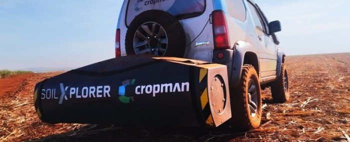
“You drive over the area in a vehicle equipped with a proximal sensor at about a meter above the ground. The intensity of the pulses that rebound correlates directly with the type of soil, compaction, clayiness, stoniness, and so on,” Franco said.
Mapping of soil variability helps farmers decide how to apply inputs to each area of cropland. Soil attributes are analyzed at different depths, producing a detailed survey of soil compaction conditions, he explained.
“We can see soil variability not visible to the naked eye, which explains why one part of an area yields 124 tons of sugarcane and another part yields only 1 ton,” he said.
With altimetric and soil sampling data collected at strategic points and fed into Smart Sampling, the output is a set of permanent management zones for a range of agricultural uses and for any crop, lowering the cost of inputs and raising yields. Cropman’s algorithms process the huge amounts of data obtained from the sensors to deliver an efficient soil diagnosis.
“We use various sensors to assess production, but our main differentiator and the main innovation in what we do resides in application of our algorithms. The secret of the service we provide is knowing what to do with the data we collect,” Franco said.
Fewer samples, more precision
In developing its algorithms, the firm emulated the methods used by the oil and gas industry to select drill sites after analyzing seismic and soil data from sensors. “Oil wells are very carefully sited. They have to be highly assertive. They feed algorithms with qualitative and quantitative data for the areas where prospecting surveys point to a high probability of finding oil. As we thought about this, it occurred to us to create algorithms fed with coordinates and soil data for agricultural properties with the aim of generating information that supports decision making by farmers,” Franco said.
During the algorithm design stage, the researchers were already able to produce maps as good as those made from dense sampling grids with data collection at 25-meter intervals but with a tenth of the number of samples. “The algorithm was fed with electrical variability data and told us where to collect samples for a highly qualified map. As a result, far fewer samples were needed,” Franco said.
In the Phase 2 PIPE project, the researchers decided to scale up the technology and put everything together in a single data management platform. The outcome was Smart Sampling, progressing from sampling grids to the establishment of precisely determined management zones.
“After applying the sensor and running the algorithm, we quickly obtained the exact points at which to collect data on the following day. These samples were analyzed in the laboratory. Based on data mining, we created polygons with the characteristics of each portion, which can receive the right inputs in the necessary amounts. No one had done this before. We realized we had created an innovation. We introduced this idea of creating management zones into the PIPE project, and intensified the automation process,” Franco said.
Cross-border partnerships
In 2019, Franco visited Austria to take a look at Geoprospector, which was developing an electromagnetic induction sensor for the Brazilian firm. The partnership pointed Cropman to CNH Industrial, an Italian multinational that owns a stake in the Austrian firm. In 2020, before the advent of the COVID-19 pandemic, Cropman contacted CNH Industrial as it was engaging in the Brazilian launch of Agxtend, an innovative platform of solutions for digital agriculture.
According to Franco, the representatives of the Italian multinational were impressed by the technological package developed by Cropman, and especially by what its algorithm could do with the data.
“They saw how Cropman’s software worked with the Austrian hardware and how our processing got even more out of Geoprospector’s sensor. They liked what they saw, and we began to discuss a partnership,” Franco recalled.
The pandemic caused a delay, but in mid-2021 the two firms signed a commercial agreement. “The partnership works like this: CNH brings us a market via its concessionaires, of which there are about 100 in Brazil and the rest of Latin America, and we operate their hardware and our software with the concessionaires’ customers,” Franco said.
The partnership led to the Agxtend Brazil Program, launched in October and also involving Case IH and New Holland Agriculture, which make agricultural machinery for the CNH Industrial group. The mapping hardware is licensed to Cropman free of charge, which is essential for the firm to acquire scale. Cropman pays the partners a fee per hectare for use of the sensor and benefits from access to the market via CNH’s concessionaires. Without this partnership, it would have taken far longer to enter the market.
“It could become a success case. It’s hard to acquire scale, but we’ve succeeded in focusing on upgrades to our processes and they’ve helped us with access to the market,” Franco said.